Orlando Kissimmee Gateway Airport (KISM / ISM)
Empty legs and charters from Orlando
KISM airport at a glance
- ICAO code
- KISM
- IATA code
- ISM
- City
- Orlando
- Region
- Florida
- Country
- United States
- Elevation
- 82 ft (25 m)
- Time zone
- America/New York (UTC-5)
- Coordinates
- 28.2898° N, 81.4371° W
- Empty legs from
- 32
- Empty legs to
- 27
Weather & airport info KISM
Current weather
Good visual conditions (VFR)observed 04 Nov, 17:56 UTC- Wind
- 5 kt (9 km/h) from east (100°)
- Visibility
- 10 km or more
- Weather
- Light rain
- Clouds
- broken clouds at 3,300 ft, overcast at 4,000 ft
- Temperature
- 28 °C (dew point 23 °C)
- Pressure (QNH)
- 1,015 hPa
Original weather report (METAR)
METAR KISM 041756Z 10005KT 10SM -RA BKN033 OVC040 28/23 A2997 RMK AO2 RAB41 SLP151 6//// T02780228 10283 20222 58023 PNO $
Forecast (TAF)
- 04 Nov, 18:00–19:00 UTC10 kt (19 km/h) from east-southeast (120°) · visibility 10 km or more · scattered clouds at 2,500 ft, scattered clouds at 25,000 ft
- 04 Nov, 19:00–00:00 UTCfrom9 kt (17 km/h) from east (100°) · visibility 10 km or more · Showers in the vicinity · scattered clouds at 3,500 ft, broken clouds at 25,000 ft
- 05 Nov, 00:00–16:00 UTCfrom4 kt (7 km/h) from east (90°) · visibility 10 km or more · few clouds at 4,000 ft, scattered clouds at 25,000 ft
- 05 Nov, 16:00–18:00 UTCfrom6 kt (11 km/h) from east (90°) · visibility 10 km or more · few clouds at 5,000 ft
Original forecast (TAF)
TAF KISM 041720Z 0418/0518 12010KT P6SM SCT025 SCT250 FM041900 10009KT P6SM VCSH SCT035 BKN250 FM050000 09004KT P6SM FEW040 SCT250 FM051600 09006KT P6SM FEW050
Airport
- Elevation
- 82 ft (25 m)
- Sunrise / Sunset
- 06:39 / 17:39 local time
Runways
| Runway | Length | Surface | Lighted |
|---|---|---|---|
| 15/33 | 1,829 m (6,001 ft) | asphalt | yes |
| 06/24 | 1,524 m (5,001 ft) | asphalt | yes |
Radio frequencies
- Clearance: 119.95
- CTAF: 124.45
- Ground: 121.7
- Tower: 124.45
- UNICOM: 122.95
For information only, not for flight planning. Weather can change quickly; always rely on official reports. Sources: aviationweather.gov (NOAA), OurAirports.
Airport map KISM
Full screen →Runways white, taxiways yellow with designators, closed taxiways and runways per NOTAM in red.
Closed per NOTAM: RWY 6/24
Official charts (FAA)
Cycle 2611, valid until 0901Z 11/26/26
Airport diagram (FAA)
Airport diagram (1)
Instrument approaches (4)
Minimums (2)
Other (19)
- ALYNA FOUR (RNAV)
- BITHO SEVEN
- JAFAR THREE (RNAV)
- JAFAR THREE (RNAV), CONT.1
- JOKRS FOUR (RNAV)
- JOKRS FOUR (RNAV), CONT.1
- LEESE THREE
- LEESE THREE, CONT.1
- MINEE SIX
- MINEE SIX, CONT.1
- MUNGI ONE (RNAV)
- MUNGI ONE (RNAV), CONT.1
- PRICY FIVE (RNAV)
- PRICY FIVE (RNAV), CONT.1
- PRICY FIVE (RNAV), CONT.2
- SHREK TWO (RNAV)
- SLOAO ONE (RNAV)
- SNFLD THREE (RNAV)
- SNFLD THREE (RNAV), CONT.1
For information only, not for navigation. Always use current official charts and NOTAMs.
Current NOTAMs for KISM(11)
NOTAMs (Notices to Air Missions) announce short-term changes at an airport: closed runways or taxiways, unserviceable approach aids, obstacles, airspace restrictions.
- ClosedRunway: closedA0421/26· from 05 Nov, 16:01 UTC · until 05 Nov, 21:00 UTC
Runway 15/33 is closed, except for crossing and taxiing. Aircraft weighing more than 12500 pounds require a 10-minute prior permission request.
Show original text
RWY 15/33 CLSD EXC XNG AND TAX AND ACFT MORE THAN 12500LB 10MIN PPR 124.45
A0421/26 NOTAMN
Q) KZJX/QMRLC////000/999/2817N08126W005
A) KISM
B) 2611051601
C) 2611052100
E) RWY 15/33 CLSD EXC XNG AND TAX AND ACFT MORE THAN 12500LB 10MIN PPR 124.45
- ClosedRunway: closedA0420/26· from 05 Nov, 12:00 UTC · until 05 Nov, 16:00 UTC
Runway 15/33 closed except TAX and XNG
Show original text
RWY 15/33 CLSD EXC TAX AND XNG
A0420/26 NOTAMN
Q) KZJX/QMRLC////000/999/2817N08126W005
A) KISM
B) 2611051200
C) 2611051600
E) RWY 15/33 CLSD EXC TAX AND XNG
- ClosedRunway: closedA0428/26· until 04 Nov, 21:00 UTC
Runway 06/24 at Kissimmee Gateway Airport is closed, except for taxiing, crossing, and helicopter operations.
Show original text
RWY 06/24 CLSD EXC TAX, XNG AND HEL OPS
A0428/26 NOTAMN
Q) KZJX/QMRLC////000/999/2817N08126W005
A) KISM
B) 2611041100
C) 2611042100
E) RWY 06/24 CLSD EXC TAX, XNG AND HEL OPS
- ClosedTaxiway: closedA0422/26· from 05 Nov, 12:00 UTC · until 05 Nov, 21:00 UTC
Taxiway A between Taxiway A3 and the Sunstate Aviation apron at Kissimmee Gateway Airport is closed.
Show original text
TWY A BTN TWY A3 AND SUNSTATE AVIATION APN CLSD
A0422/26 NOTAMN
Q) KZJX/QMXLC////000/999/2817N08126W005
A) KISM
B) 2611051200
C) 2611052100
E) TWY A BTN TWY A3 AND SUNSTATE AVIATION APN CLSD
- Out of servicePAPI: unserviceableA0427/26· until 02 Feb, 23:59 UTC
The PAPI (Precision Approach Path Indicator) for runway 33 is out of service. PAPI lights help pilots maintain the correct glide path to the runway.
Show original text
RWY 33 PAPI U/S
A0427/26 NOTAMN
Q) KZJX/QLPAS////000/999/2817N08126W005
A) KISM
B) 2611021945
C) 2702022359
E) RWY 33 PAPI U/S
- Out of serviceWind indicator: not available10/023· until 26 Nov, 23:59 UTC
The ceiling information is not available from the automated weather broadcast system.
Show original text
SVC AUTOMATED WX BCST SYSTEM CEILING NOT AVBL
A0406/26 NOTAMN Q) KZJX/QFWAU////000/999/2817N08126W005 A) KISM B) 2610191730 C) 2611262359 E) SVC AUTOMATED WX BCST SYSTEM CEILING NOT AVBL
- Out of serviceAerodrome beacon: unserviceableA0397/26· until 14 Dec, 15:18 UTC
The airport beacon (ABN) is out of service.
Show original text
AD AP ABN U/S
A0397/26 NOTAMN
Q) KZJX/QLBAS////000/999/2817N08126W005
A) KISM
B) 2610121519
C) 2612141518
E) AD AP ABN U/S
- Out of servicePAPI: unserviceableA0394/26· until 30 Nov, 23:59 UTC
The PAPI (Precision Approach Path Indicator) for runway 15 is out of service. The PAPI is a system that provides pilots with visual guidance for the correct approach angle to the runway.
Show original text
RWY 15 PAPI U/S
A0394/26 NOTAMN
Q) KZJX/QLPAS////000/999/2817N08126W005
A) KISM
B) 2610112042
C) 2611302359
E) RWY 15 PAPI U/S
3 more NOTAMs
- Out of serviceObstacle10/001· until 30 Nov, 23:59 UTC
The lighting on a tower obstacle 3.2 nautical miles north-northeast of the airport is out of service. Its top is 320.9 ft above sea level, 235.9 ft above ground.
Show original text
OBST TOWER LGT (ASR 1213722) 282002.00N0812421.20W (3.2NM NNE ISM) 320.9FT (235.9FT AGL) U/S
- Out of serviceObstacle09/040· until 13 Nov, 23:59 UTC
A tower light (obstacle lighting) 16.8 nautical miles northwest of the airport is out of service. The top of the tower is 486 ft above sea level, 340 ft above ground.
Show original text
OBST TOWER LGT (ASN 2026-ASO-4950-OE) 282657N0814218W (16.8NM NW ISM) 486FT (340FT AGL) U/S
- NoticeTaxiwayA0426/26· until 06 Nov, 23:00 UTC
Taxiway A between Taxiway A2 and Taxiway A3 has an irregular surface with a 1/2 inch depression. This might affect aircraft taxiing.
Show original text
TWY A BTN TWY A2 AND TWY A3 IRREGULAR SFC 1/2IN DEPRESSION
A0426/26 NOTAMN
Q) KZJX/QMXXX////000/999/2817N08126W005
A) KISM
B) 2611021945
C) 2611062300
E) TWY A BTN TWY A2 AND TWY A3 IRREGULAR SFC 1/2IN DEPRESSION
For information only, not for flight planning or operational use. Always rely on an official pre-flight briefing. This list may be incomplete or out of date. Explanations and expanded abbreviations are generated automatically. The original text is authoritative. Source: FAA NOTAM Management Service (SWIM).
Private jet traffic in Kissimmee Gateway Airport (last 30 days)
- Arrivals
- 617
- Departures
- 548
- Different jets
- 517
Most frequent origins: Miami-Opa Locka Executive Airport (18), Naples Municipal Airport (13), Fort Lauderdale Hollywood International Airport (13), Fort Lauderdale Executive Airport (11), Palm Beach International Airport (10).
Most frequent destinations: Miami-Opa Locka Executive Airport (16), DeKalb Peachtree Airport (12), Naples Municipal Airport (12), Palm Beach International Airport (12), Northwest Florida Beaches International Airport (8).
Most common aircraft types: Cirrus Vision Jet (102), Cessna Citation Excel/XLS (73), Embraer Phenom 300 (67), Bombardier Challenger 350/3500 (56), Pilatus PC-12 (53).
Sunday is the busiest day.
Our own analysis of public ADS-B signals from business jets. Not every flight is received, and jets with a removal request are excluded.
Charter operators based here
Operators with a base at this airport.
- Aloft Aviation ServicesPiston aircraft
- Sky Travel SolutionsLight jet
- Trans North AviationDenver (Centennial) (KAPA) · Turboprop, Light jet
Empty legs from KISM
32 departures available
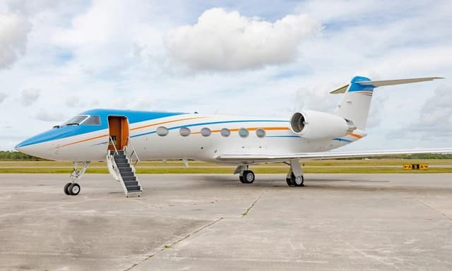 Wed, Nov 4TodayOrlandoKISM · Kissimmee Gateway AirportNew YorkKTEB · Teterboro AirportGulfstream GIV-SP13—$32,9624NovOrlando → New YorkKISM → KTEB · TodayGulfstream GIV-SP · 13 seats$32,962
 Wed, Nov 4TodayOrlandoKISM · Kissimmee Gateway AirportLos AngelesKVNY · Van Nuys AirportGulfstream GIV-SP12—$55,3764NovOrlando → Los AngelesKISM → KVNY · TodayGulfstream GIV-SP · 12 seats$55,376
- Thu, Nov 5TomorrowOrlandoKISM · Kissimmee GatewayAtlantaKATA · Hall - Miller MuniSuper Midsize Jet6—On request5NovOrlando → AtlantaKISM → KATA · TomorrowSuper Midsize Jet · 6 seatsOn request
- Fri, Nov 6in 2 daysOrlandoKISM · Kissimmee Gateway AirportNashvilleKM77 · Howard County AirportBeechcraft Hawker 900XP8—$11,8806NovOrlando → NashvilleKISM → KM77 · in 2 daysBeechcraft Hawker 900XP · 8 seats$11,880
- Fri, Nov 6in 2 daysOrlandoKISM · Kissimmee GatewayFort LauderdaleKFLL · Hollywood IntlLight Jet6—On request6NovOrlando → Fort LauderdaleKISM → KFLL · in 2 daysLight Jet · 6 seatsOn request
- Fri, Nov 6in 2 daysOrlandoKISM · Kissimmee GatewayNashvilleKBNA · Nashville IntlUltra Long Range Jet6—On request6NovOrlando → NashvilleKISM → KBNA · in 2 daysUltra Long Range Jet · 6 seatsOn request
- Sun, Nov 8in 4 daysOrlandoKISM · Kissimmee GatewayFort LauderdaleKFLL · Hollywood IntlMidsize Jet6—On request8NovOrlando → Fort LauderdaleKISM → KFLL · in 4 daysMidsize Jet · 6 seatsOn request
- Mon, Nov 9in 5 daysOrlandoKISM · Kissimmee Gateway AirportTeterboroKTEB · Teterboro AirportBombardier Challenger 60512—$17,3809NovOrlando → TeterboroKISM → KTEB · in 5 daysBombardier Challenger 605 · 12 seats$17,380
- Mon, Nov 9in 5 daysOrlandoKISM · Kissimmee GatewayFort LauderdaleKFLL · Hollywood IntlMidsize Jet6—On request9NovOrlando → Fort LauderdaleKISM → KFLL · in 5 daysMidsize Jet · 6 seatsOn request
 KISM · Kissimmee Gateway Airport
* Total price incl. 10% service fee, converted to your selected currency. Price subject to operator confirmation.
Empty legs to KISM
27 arrivals available
 Wed, Nov 4TodayMiamiKOPF · Miami-Opa Locka Executive AirportOrlandoKISM · Kissimmee Gateway AirportHawker 800XP8—On request4NovMiami → OrlandoKOPF → KISM · TodayHawker 800XP · 8 seatsOn request
- Wed, Nov 419:18West Palm BeachKDJT · President Donald J. Trump International AirportOrlandoKISM · Kissimmee GatewayBombardier Learjet 607—$5,4454NovWest Palm Beach → OrlandoKDJT → KISM · 19:18Bombardier Learjet 60 · 7 seats$5,445
 Wed, Nov 423:42Kansas CityKMKC · Charles B. Wheeler Downtown AirportOrlandoKISM · Kissimmee Gateway AirportBombardier Challenger 350010—On request4NovKansas City → OrlandoKMKC → KISM · 23:42Bombardier Challenger 3500 · 10 seatsOn request
- Thu, Nov 5TomorrowKansas CityKMKC · Charles B. Wheeler Downtown AirportOrlandoKISM · Kissimmee Gateway AirportBombardier Challenger 35009—$16,3905NovKansas City → OrlandoKMKC → KISM · TomorrowBombardier Challenger 3500 · 9 seats$16,390
- Thu, Nov 5TomorrowMiamiKMIA · Miami IntlOrlandoKISM · Kissimmee GatewaySuper Midsize Jet6—On request5NovMiami → OrlandoKMIA → KISM · TomorrowSuper Midsize Jet · 6 seatsOn request
- Thu, Nov 5TomorrowKansas CityKMKC · Charles B. Wheeler Downtown AirportOrlandoKISM · Kissimmee Gateway AirportBombardier Inc Challenger 300/3508—On request5NovKansas City → OrlandoKMKC → KISM · TomorrowBombardier Inc Challenger 300/350 · 8 seatsOn request
- Fri, Nov 6in 2 daysTitusvilleKTIX · Space Coast RegionalOrlandoKISM · Kissimmee GatewayMidsize Jet6—On request6NovTitusville → OrlandoKTIX → KISM · in 2 daysMidsize Jet · 6 seatsOn request
- Sat, Nov 719:51New OrleansKNEW · Lakefront AirportOrlandoKISM · Kissimmee Gateway AirportBombardier Learjet 607—$15,6207NovNew Orleans → OrlandoKNEW → KISM · 19:51Bombardier Learjet 60 · 7 seats$15,620
- Sat, Nov 7in 3 daysAtlantaKATA · Hall - Miller MuniOrlandoKISM · Kissimmee GatewaySuper Midsize Jet6—On request7NovAtlanta → OrlandoKATA → KISM · in 3 daysSuper Midsize Jet · 6 seatsOn request
* Total price incl. 10% service fee, converted to your selected currency. Price subject to operator confirmation.
Map: Orlando Airport
View the location of Orlando – ISM/KISM. Zoom in to explore the area around the airport.
About the airport
Kissimmee Gateway Airport (ISM/KISM) is the key private jet gateway for Orlando. PrivJet gives you instant access to charter flights and empty legs: fast, discreet and globally connected.
KISM airport FAQ
Are there any restrictions at Orlando airport (KISM) today?
There are currently 8 valid NOTAMs for Orlando (KISM). According to NOTAM, at least one runway or the aerodrome itself is closed. Affected: Runway: closed; PAPI: unserviceable; Wind indicator: not available; Aerodrome beacon: unserviceable and 1 more. 3 more NOTAMs start in the coming days. For information only, not for flight planning or operational use. Always rely on an official pre-flight briefing. This list may be incomplete or out of date.
What is the weather at Orlando airport (KISM)?
According to the latest weather report for KISM (METAR, 04 Nov, 17:56 UTC): Good visual conditions (VFR). Wind 5 kt (9 km/h) from east (100°), visibility 10 km or more, temperature 28 °C (dew point 23 °C). Light rain. For information only, not for flight planning. Weather can change quickly; always rely on official reports.
How long are the runways at Orlando airport (KISM)?
Orlando (KISM) has 2 runways: runway 15/33 with 1,829 m (6,001 ft), asphalt and runway 06/24 with 1,524 m (5,001 ft), asphalt. The longest is 1,829 m.
What are the radio frequencies at Orlando airport (KISM)?
Frequencies at KISM: Tower 124.45 MHz and Ground 121.7 MHz. For information only. Always rely on the published AIP.
What are the airport codes of Kissimmee Gateway Airport?
The ICAO code is KISM and the IATA code is ISM. ICAO codes are used by air traffic control and pilots, e.g. in flight plans; IATA codes appear on tickets and baggage tags.
What is the elevation of KISM airport?
Kissimmee Gateway Airport sits at 82 ft (25 m) above sea level. Local time zone: America/New York.
Can I fly to KISM by private jet?
Whether a private jet can operate into Kissimmee Gateway Airport depends on runway length, opening hours, customs and immigration rules as well as slot and handling availability, among other things. PrivJet checks this with the operating carrier for every request.
Are there empty legs from or to KISM?
There are currently 32 empty legs departing from and 27 arriving at Kissimmee Gateway Airport. Empty legs are repositioning flights at heavily reduced prices; the list is updated several times a day.