San Antonio Airport (KSAT / SAT)
Empty legs and charters from San Antonio
KSAT airport at a glance
- ICAO code
- KSAT
- IATA code
- SAT
- City
- San Antonio
- Region
- Texas
- Country
- United States
- Elevation
- 809 ft (247 m)
- Time zone
- America/Chicago (UTC-6)
- Coordinates
- 29.5337° N, 98.4698° W
- Empty legs from
- 100
- Empty legs to
- 100
Private jet terminal & FBOs at San Antonio
- Signature Aviation SAT North557 Sandau Road, San Antonio, TX 78216
- Signature Aviation SAT South1115 Paul Wilkins Road, San Antonio, TX 78216
- Million Air San Antonio8901 Wetmore Road, San Antonio, TX 78216
Weather & airport info KSAT
Current weather
Good visual conditions (VFR)observed 03 Nov, 20:51 UTC- Wind
- 7 kt (13 km/h) from north-northwest (330°)
- Visibility
- 10 km or more
- Clouds
- no significant clouds
- Temperature
- 28 °C (dew point 10 °C)
- Pressure (QNH)
- 1,013 hPa
Original weather report (METAR)
METAR KSAT 032051Z 33007KT 10SM CLR 28/10 A2990 RMK AO2 SLP105 T02830100 56018
Forecast (TAF)
- 03 Nov, 21:00–00:00 UTC8 kt (15 km/h) from north-northwest (330°) · visibility 10 km or more · few clouds at 25,000 ft
Original forecast (TAF)
TAF KSAT 032056Z 0321/0424 33008KT P6SM FEW250
Airport
- Elevation
- 809 ft (247 m)
- Sunrise / Sunset
- 06:48 / 17:46 local time
Runways
| Runway | Length | Surface | Lighted |
|---|---|---|---|
| 04/22 | 2,592 m (8,505 ft) | concrete | yes |
| 13R/31L | 2,591 m (8,502 ft) | concrete | yes |
| 13L/31R | 1,682 m (5,519 ft) | asphalt | yes |
Radio frequencies
- ATIS: 118.9
- Clearance: 126.7
- Ground: 121.9
- Tower: 119.8
- UNICOM: 122.95
For information only, not for flight planning. Weather can change quickly; always rely on official reports. Sources: aviationweather.gov (NOAA), OurAirports.
Airport map KSAT
Full screen →Runways white, taxiways yellow with designators, closed taxiways and runways per NOTAM in red.
Closed per NOTAM: RWY 4/22
Official charts (FAA)
Cycle 2611, valid until 0901Z 11/26/26
Airport diagram (FAA)
Airport diagram (1)
Instrument approaches (13)
Departure procedures (10)
Minimums (2)
Hot spots (1)
Other (16)
- CENTERPOINT THREE
- CRVZA TWO (RNAV)
- CRVZA TWO (RNAV), CONT.1
- CRVZA TWO (RNAV), CONT.2
- DNKIN TWO (RNAV)
- DNKIN TWO (RNAV), CONT.1
- LEMIG TWO
- MARCS TWO
- MARCS TWO, CONT.1
- POPPO TWO (RNAV)
- POPPO TWO (RNAV), CONT.1
- POPPO TWO (RNAV), CONT.2
- QERVO THREE (RNAV)
- QERVO THREE (RNAV), CONT.1
- QERVO THREE (RNAV), CONT.2
- STONEWALL TWO
For information only, not for navigation. Always use current official charts and NOTAMs.
Current NOTAMs for KSAT(16)
NOTAMs (Notices to Air Missions) announce short-term changes at an airport: closed runways or taxiways, unserviceable approach aids, obstacles, airspace restrictions.
- ClosedRunway: closedA1753/26· from 05 Nov, 13:00 UTC · until 06 Nov, 01:00 UTC
Runway 04/22 is closed.
Show original text
RWY 04/22 CLSD
A1753/26 NOTAMN
Q) KZHU/QMRLC////000/999/2932N09828W005
A) KSAT
B) 2611051300
C) 2611060100
E) RWY 04/22 CLSD
- ClosedRunway: closedA1752/26· from 04 Nov, 13:00 UTC · until 05 Nov, 01:00 UTC
Runway 04/22 is closed. This means aircraft cannot use this runway at the moment.
Show original text
RWY 04/22 CLSD
A1752/26 NOTAMN
Q) KZHU/QMRLC////000/999/2932N09828W005
A) KSAT
B) 2611041300
C) 2611050100
E) RWY 04/22 CLSD
- ClosedRunway: closedA1751/26· until 04 Nov, 01:00 UTC
Runway 04/22 is closed.
Show original text
RWY 04/22 CLSD
A1751/26 NOTAMN
Q) KZHU/QMRLC////000/999/2932N09828W005
A) KSAT
B) 2611031300
C) 2611040100
E) RWY 04/22 CLSD
- Out of serviceTerminal area surveillance radar: unserviceableA1735/26· from 07 Nov, 13:00 UTC · until 07 Nov, 23:00 UTC
The secondary surveillance radar (TAR/SSR), a system for monitoring air traffic, is out of service.
Show original text
SVC TAR/SSR U/S
A1735/26 NOTAMN
Q) KZHU/QCTAS////000/999/2932N09828W005
A) KSAT
B) 2611071300
C) 2611072300
E) SVC TAR/SSR U/S
- Out of serviceAerodrome: not availableA1736/26· from 07 Nov, 13:00 UTC · until 07 Nov, 23:00 UTC
The microburst and wind shear detection system is not available.
Show original text
SVC MBST/WS DETECTION SYSTEM NOT AVBL
A1736/26 NOTAMN
Q) KZHU/QFMAU////000/999/2932N09828W005
A) KSAT
B) 2611071300
C) 2611072300
E) SVC MBST/WS DETECTION SYSTEM NOT AVBL
- Out of serviceObstacle10/123· until 19 Dec, 23:59 UTC
A tower 7.9 nautical miles west of the airport has a light that is out of service. Its top is 1113.2 ft above sea level, 205.1 ft above ground.
Show original text
OBST TOWER LGT (ASR 1052545) 293131.20N0983706.60W (7.9NM W SAT) 1113.2FT (205.1FT AGL) U/S
10/123 NOTAMN<BR>
<B>Q) </B>KZHU/QOLAS/IV/M/E/000/012/2932N09828W005<BR>
<B>A) </B>KSAT<BR>
<B>B) </B>2610301301<BR>
<B>C) </B>2612192359<BR>
<B>E) </B> TOWER LGT (ASR 1052545) 293131.20N0983706.60W (7.9NM W SAT) 1113.2FT (205.1FT AGL) U/S<BR>
- Out of serviceObstacle10/124· until 19 Dec, 23:59 UTC
A tower 7.9 nautical miles west of the airport has a light that is out of service. Its top is 1321.2 ft above sea level, 413.1 ft above ground.
Show original text
OBST TOWER LGT (ASR 1238562) 293132.90N0983707.40W (7.9NM W SAT) 1321.2FT (413.1FT AGL) U/S
10/124 NOTAMN<BR>
<B>Q) </B>KZHU/QOLAS/IV/M/E/000/014/2932N09828W005<BR>
<B>A) </B>KSAT<BR>
<B>B) </B>2610301301<BR>
<B>C) </B>2612192359<BR>
<B>E) </B> TOWER LGT (ASR 1238562) 293132.90N0983707.40W (7.9NM W SAT) 1321.2FT (413.1FT AGL) U/S<BR>
- Out of serviceObstacle10/122· until 19 Dec, 23:59 UTC
A tower 7.9 nautical miles west of the airport has a light that is out of service. Its top is 1110.9 ft above sea level, 205.1 ft above ground.
Show original text
OBST TOWER LGT (ASR 1052544) 293129.60N0983705.80W (7.9NM W SAT) 1110.9FT (205.1FT AGL) U/S
8 more NOTAMs
- Out of serviceObstacle10/120· until 19 Dec, 23:59 UTC
A tower 8.0 nautical miles west of the airport has a light that is out of service. Its top is 1113.2 ft above sea level, 205.1 ft above ground.
Show original text
OBST TOWER LGT (ASR 1052542) 293127.90N0983711.00W (8.0NM W SAT) 1113.2FT (205.1FT AGL) U/S
- Out of serviceObstacle10/121· until 19 Dec, 23:59 UTC
A tower 8.0 nautical miles west of the airport has a light that is out of service. Its top is 1117.1 ft above sea level, 205.1 ft above ground.
Show original text
OBST TOWER LGT (ASR 1052543) 293129.60N0983711.80W (8.0NM W SAT) 1117.1FT (205.1FT AGL) U/S
- Out of serviceObstacle10/119· until 19 Dec, 23:59 UTC
A tower 8.0 nautical miles west of the airport is out of service. Its top is 1104.0 feet above sea level, 205.1 feet above ground.
Show original text
OBST TOWER LGT (ASR 1052541) 293126.30N0983710.20W (8.0NM W SAT) 1104.0FT (205.1FT AGL) U/S
- Out of serviceInstrument approach procedure5112/26· until 10 Nov, 20:00 UTC
Instrument approach procedure SAN ANTONIO INTL, SAN ANTONIO, TX. ILS (instrument landing system) or localizer runway 13R, amendment 15... ILS (instrument landing system) runway 13R (category II) amendment 15... ALTERNATE MINIMUMS not available except for aircraft equipped with SUITABLE RNAV (area navigation) SYSTEM with GPS, SSF VOR beacon UNMONITORED. 3 Nov 19:17 UTC -2611102000EST
Show original text
IAP SAN ANTONIO INTL, SAN ANTONIO, TX. ILS OR LOC RWY 13R, AMDT 15... ILS RWY 13R (CAT II) AMDT 15... ALTERNATE MINIMUMS NA EXCEPT FOR ACFT EQUIPPED WITH SUITABLE RNAV SYSTEM WITH GPS, SSF VOR UNMONITORED. 2611031917-2611102000EST
Q) KZHU/QPIXX/I/NBO/A/000/999/2932N09828W005
A) KSAT
B) 2405221630
C) 2406201630EST
E) SAT SAN ANTONIO INTL, SAN ANTONIO, TX.
ILS OR LOC RWY 13R, AMDT 15...
ILS RWY 13R (CAT II) AMDT 15...
ALTERNATE MNM NA EXCEPT FOR ACFT EQUIPPED WITH SUITABLE RNAV SYSTEM WITH GPS,
SSF VOR NOT MNT.
- Out of serviceInstrument approach procedure: changedA1760/26· until 10 Nov, 20:00 UTC
Instrument approach procedure SAN ANTONIO INTL, SAN ANTONIO, TX. ILS (instrument landing system) or localizer runway 13R, amendment 15... ILS (instrument landing system) runway 13R (category II) amendment 15... ALTERNATE MINIMUMS not available except for aircraft equipped with SUITABLE RNAV (area navigation) SYSTEM with GPS, SSF VOR beacon UNMONITORED.
Show original text
IAP SAN ANTONIO INTL, SAN ANTONIO, TX. ILS OR LOC RWY 13R, AMDT 15... ILS RWY 13R (CAT II) AMDT 15... ALTERNATE MINIMUMS NA EXCEPT FOR ACFT EQUIPPED WITH SUITABLE RNAV SYSTEM WITH GPS, SSF VOR UNMONITORED.
A1760/26 NOTAMN
Q) KZHU/QPICH/I/NBO/A/000/999/2932N09828W005
A) KSAT
B) 2611031917
C) 2611102000
E) IAP SAN ANTONIO INTL, SAN ANTONIO, TX. ILS OR LOC RWY 13R, AMDT 15... ILS RWY 13R (CAT II) AMDT 15... ALTERNATE MINIMUMS NA EXCEPT FOR ACFT EQUIPPED WITH SUITABLE RNAV SYSTEM WITH GPS, SSF VOR UNMONITORED.
- NoticeRunwayA1726/26· until 13 Nov, 22:00 UTC
The runway 04/22 edge markings are not standard.
Show original text
RWY 04/22 EDGE MARKINGS NOT STD
A1726/26 NOTAMN
Q) KZHU/QMRXX////000/999/2932N09828W005
A) KSAT
B) 2610311200
C) 2611132200
E) RWY 04/22 EDGE MARKINGS NOT STD
- NoticeTaxiway10/127· until 06 Nov, 23:00 UTC
The taxiway Q shoulder markings are not standard.
Show original text
TWY Q SHOULDER MARKINGS NOT STD
- NoticeObstacle: erectedA1571/26· until 01 Dec, 23:00 UTC
A crane is located 0.6 nautical miles southwest of the airport. Its top is 971 ft above sea level, 165 ft above ground, and it is flagged and lighted.
Show original text
OBST CRANE (ASN 2026-ASW-1387-NRA) 293141N0982839W (0.6NM SW SAT) 971FT (165FT AGL) FLAGGED AND LGTD
A1571/26 NOTAMN
Q) KZHU/QOBCE/IV/M/AE/000/999/2932N09828W005
A) KSAT
B) 2610051100
C) 2612012300
D) DLY 1100-2300
E) OBST CRANE (ASN 2026-ASW-1387-NRA) 293141N0982839W (0.6NM SW SAT) 971FT (165FT AGL) FLAGGED AND LGTD
Hours: DLY 1100-2300
For information only, not for flight planning or operational use. Always rely on an official pre-flight briefing. This list may be incomplete or out of date. Explanations and expanded abbreviations are generated automatically. The original text is authoritative. Source: FAA NOTAM Management Service (SWIM).
Private jet traffic in San Antonio International Airport (last 30 days)
- Arrivals
- 1,569
- Departures
- 1,346
- Different jets
- 928
Most frequent origins: Dallas Love Field (76), Laredo International Airport (63), Austin Bergstrom International Airport (57), Del Norte International Airport (51), William P Hobby Airport (49).
Most frequent destinations: Dallas Love Field (96), William P Hobby Airport (58), Austin Bergstrom International Airport (48), Del Norte International Airport (48), Laredo International Airport (37).
Most common aircraft types: Pilatus PC-12 (184), Cessna Citation III/VI/VII (155), Embraer Phenom 300 (153), Cessna Citation Excel/XLS (150), Beechcraft King Air 200/250 (135).
Our own analysis of public ADS-B signals from business jets. Not every flight is received, and jets with a removal request are excluded.
Charter operators based here
Operators with a base at this airport.
- Solairus AviationVan Nuys (KVNY) · Turboprop, Light jet, Midsize jet
- Wing Aviation Charter ServicesHouston (William P Hobby) (KHOU) · Turboprop, Light jet, Midsize jet
- Paradigm Jet ManagementAustin (Bergstrom) (KAUS) · Turboprop, Light jet, Midsize jet
- Encore JetLight jet, Midsize jet
- Merlin OneMidsize jet
- Business JetDallas (Love Field) (KDAL) · Super midsize jet, Heavy jet
- Omni Private AviationTulsa International (KTUL) · Light jet
- Fly Hangar 13Austin (Bergstrom) (KAUS) · Helicopter
- Aircraft Transport ServiceNashville International (KBNA) · Heavy jet
- Stargazer AviationSuper midsize jet
- AirMed InternationalBirmingham-Shuttlesworth International (KBHM) · Turboprop, Light jet, Midsize jet
Empty legs from KSAT
100 departures available
 Tue, Nov 3TodaySan AntonioKSAT · San Antonio International AirportSan DiegoKSAN · San Diego International AirportCitation VII9—On request3NovSan Antonio → San DiegoKSAT → KSAN · TodayCitation VII · 9 seatsOn request
 Tue, Nov 3TodaySan AntonioKSAT · San Antonio International AirportHoustonKHOU · William P Hobby AirportCitation XLS9—$5,5003NovSan Antonio → HoustonKSAT → KHOU · TodayCitation XLS · 9 seats$5,500
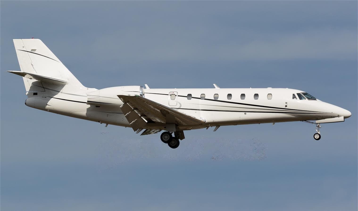 Tue, Nov 3TodaySan AntonioKSAT · San Antonio International AirportLincolnKLNK · Lincoln AirportCitation Sovereign9—$17,7103NovSan Antonio → LincolnKSAT → KLNK · TodayCitation Sovereign · 9 seats$17,710
- Tue, Nov 3TodaySan AntonioKSAT · San Antonio International AirportDallasKDAL · Dallas Love FieldBeechcraft Beechjet 400A754mOn request3NovSan Antonio → DallasKSAT → KDAL · TodayBeechcraft Beechjet 400A · 7 seats · 54mOn request
- Tue, Nov 3TodaySan AntonioKSAT · San Antonio International AirportHoustonKDWH · David Wayne Hooks Memorial AirportBeechcraft Hawker 400XP748mOn request3NovSan Antonio → HoustonKSAT → KDWH · TodayBeechcraft Hawker 400XP · 7 seats · 48mOn request
- Tue, Nov 315:00San AntonioKSAT · San Antonio International AirportSan DiegoKSAN · San Diego International AirportCessna Citation 6508—$11,8803NovSan Antonio → San DiegoKSAT → KSAN · 15:00Cessna Citation 650 · 8 seats$11,880
- Wed, Nov 406:15San AntonioKSAT · San Antonio International AirportHoustonKDWH · David Wayne Hooks Memorial AirportHawker 400XP7—$9,0204NovSan Antonio → HoustonKSAT → KDWH · 06:15Hawker 400XP · 7 seats$9,020
 Wed, Nov 422:20San AntonioKSAT · San Antonio International AirportDallasKDAL · Dallas Love FieldBeechcraft Beechjet 400A148mOn request4NovSan Antonio → DallasKSAT → KDAL · 22:20Beechcraft Beechjet 400A · 1 seat · 48mOn request
- Wed, Nov 405:00San AntonioKSAT · San Antonio IntlSan DiegoKSAN · San Diego IntlCessna Citation VII9—On request4NovSan Antonio → San DiegoKSAT → KSAN · 05:00Cessna Citation VII · 9 seatsOn request
 KSAT · San Antonio International Airport
* Total price incl. 10% service fee, converted to your selected currency. Price subject to operator confirmation.
Empty legs to KSAT
100 arrivals available
 Tue, Nov 3TodayMidlandKMDD · Midland AirparkSan AntonioKSAT · San Antonio International AirportHawker 4008—On request3NovMidland → San AntonioKMDD → KSAT · TodayHawker 400 · 8 seatsOn request
- Tue, Nov 322:45MidlandKMDD · Midland AirparkSan AntonioKSAT · San Antonio International AirportBeechcraft Beechjet 400A148mOn request3NovMidland → San AntonioKMDD → KSAT · 22:45Beechcraft Beechjet 400A · 1 seat · 48mOn request
- Tue, Nov 305:00CharlestonKCHS · Charleston IntlSan AntonioKSAT · San Antonio IntlCessna Citation III9—On request3NovCharleston → San AntonioKCHS → KSAT · 05:00Cessna Citation III · 9 seatsOn request
- Tue, Nov 3TodayMidlandKMDD · Midland AirparkSan AntonioKSAT · San Antonio International AirportRaytheon Aircraft Company Hawker 400A10—On request3NovMidland → San AntonioKMDD → KSAT · TodayRaytheon Aircraft Company Hawker 400A · 10 seatsOn request
 Wed, Nov 4TomorrowDallasKRBD · Dallas Executive AirportSan AntonioKSAT · San Antonio International AirportPilatus PC-128—$3,3004NovDallas → San AntonioKRBD → KSAT · TomorrowPilatus PC-12 · 8 seats$3,300
 Wed, Nov 4TomorrowHoustonKHOU · William P Hobby AirportSan AntonioKSAT · San Antonio International AirportChallenger 3008—On request4NovHouston → San AntonioKHOU → KSAT · TomorrowChallenger 300 · 8 seatsOn request
- Wed, Nov 4TomorrowDallasKRBD · Dallas ExecutiveSan AntonioKSAT · San Antonio IntlPilatus PC-12/47 NG——$3,3004NovDallas → San AntonioKRBD → KSAT · TomorrowPilatus PC-12/47 NG$3,300
 Wed, Nov 420:57HoustonKDWH · David Wayne Hooks Memorial AirportSan AntonioKSAT · San Antonio International AirportBeechcraft Hawker 400XP142mOn request4NovHouston → San AntonioKDWH → KSAT · 20:57Beechcraft Hawker 400XP · 1 seat · 42mOn request
 Wed, Nov 423:36DallasKRBD · Dallas Executive AirportSan AntonioKSAT · San Antonio International AirportPilatus PC 12 NG11h 18m$3,6964NovDallas → San AntonioKRBD → KSAT · 23:36Pilatus PC 12 NG · 1 seat · 1h 18m$3,696
* Total price incl. 10% service fee, converted to your selected currency. Price subject to operator confirmation.
Map: San Antonio Airport
View the location of San Antonio – SAT/KSAT. Zoom in to explore the area around the airport.
About the airport
San Antonio International Airport (SAT/KSAT) is the key private jet gateway for San Antonio. PrivJet gives you instant access to charter flights and empty legs: fast, discreet and globally connected.
KSAT airport FAQ
Are there any restrictions at San Antonio airport (KSAT) today?
There are currently 12 valid NOTAMs for San Antonio (KSAT). According to NOTAM, at least one runway or the aerodrome itself is closed. Affected: Runway: closed; Obstacle: out of service; Instrument approach procedure; Instrument approach procedure: changed. 4 more NOTAMs start in the coming days. For information only, not for flight planning or operational use. Always rely on an official pre-flight briefing. This list may be incomplete or out of date.
What is the weather at San Antonio airport (KSAT)?
According to the latest weather report for KSAT (METAR, 03 Nov, 20:51 UTC): Good visual conditions (VFR). Wind 7 kt (13 km/h) from north-northwest (330°), visibility 10 km or more, temperature 28 °C (dew point 10 °C). For information only, not for flight planning. Weather can change quickly; always rely on official reports.
How long are the runways at San Antonio airport (KSAT)?
San Antonio (KSAT) has 3 runways: runway 04/22 with 2,592 m (8,505 ft), concrete, runway 13R/31L with 2,591 m (8,502 ft), concrete and runway 13L/31R with 1,682 m (5,519 ft), asphalt. The longest is 2,592 m.
What are the radio frequencies at San Antonio airport (KSAT)?
Frequencies at KSAT: Tower 119.8 MHz, Ground 121.9 MHz and ATIS 118.9 MHz. For information only. Always rely on the published AIP.
What are the airport codes of San Antonio International Airport?
The ICAO code is KSAT and the IATA code is SAT. ICAO codes are used by air traffic control and pilots, e.g. in flight plans; IATA codes appear on tickets and baggage tags.
What is the elevation of KSAT airport?
San Antonio International Airport sits at 809 ft (247 m) above sea level. Local time zone: America/Chicago.
Where do private jets land at San Antonio?
KSAT has 3 private jet terminals or FBOs: Signature Aviation SAT North, Signature Aviation SAT South and Million Air San Antonio. Your flight confirmation says which one your operator uses.
Can I fly to KSAT by private jet?
Whether a private jet can operate into San Antonio International Airport depends on runway length, opening hours, customs and immigration rules as well as slot and handling availability, among other things. PrivJet checks this with the operating carrier for every request.
Are there empty legs from or to KSAT?
There are currently 100 empty legs departing from and 100 arriving at San Antonio International Airport. Empty legs are repositioning flights at heavily reduced prices; the list is updated several times a day.